home
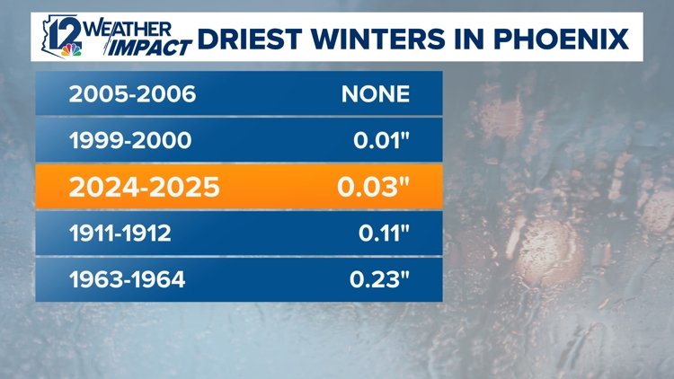
Phoenix Faces Record-Breaking Dry Spell: Third Driest Winter Under La Niña

What does the third driest winter on record mean for you? 12News Meteorologist Chris Dunn explains.
PHOENIX — Arizona’s meteorological winter, spanning from December through February, marks one of the driest on record. Specifically, Phoenix has recorded its third driest winter season, prompting concerns among residents and officials about the upcoming spring and summer heat.
The region’s lack of rainfall raises alarms, with extended periods devoid of measurable precipitation. Meteorologists attribute this dry spell to several factors, primarily the effects of La Niña.
“We’re seeing the effects of a typical La Niña pattern,” stated 12News meteorologist Chris Dunn. “The main storm track has remained well to the north all winter, funneling storms into the Pacific Northwest instead of Arizona. This diversion has substantially reduced precipitation across the Southwest, including our state.”
La Niña, characterized by cooler-than-average sea surface temperatures in the central and eastern Pacific, commonly leads to drier conditions in the Southwest U.S. Flagstaff has not been spared; it logged just 11.2 inches of snow this winter, far below the typical 68.4 inches.
The repercussions of this exceptionally dry winter are significant:
- Water Resources: Lower rain and snow levels may result in diminished water supplies for agriculture and urban areas.
- Wildfire Risk: Increased dryness elevates the chances of wildfires, threatening communities and ecosystems alike.
- Agriculture: Farmers may struggle with irrigation needs and face reduced crop yields.
Looking ahead, the spring forecast is troubling. NOAA’s Climate Prediction Center anticipates a high likelihood of continued dry and warm conditions. Over half the state currently faces “extreme” drought, suggesting little improvement in the near future.


