arizona
High Country Storms Wrap Up Season’s First Monsoon Surge

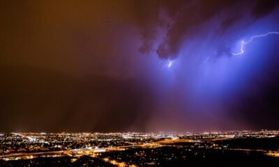
PHOENIX — Weather conditions across Arizona have stabilized, with Thursday storms affecting only the High Country and southeastern regions. The remainder of the state will experience dry and clear weather as we approach Independence Day.
Drier air from the west is expected to eliminate chances for any storms by Friday. For the 4th of July, temperatures will hover near average, with reduced humidity across the Valley. This trend will continue into the holiday weekend before more extreme heat sets in.
A Weather Impact Alert will be in effect from Monday to Wednesday. Valley highs are projected to reach between 112-115 degrees, while morning lows may stay around 90. Although these temperatures are not record-breaking, they pose health risks for those planning outdoor activities.
Seven-Day Forecast:
FRIDAY: 104/85 A dry 4th of July
SATURDAY: 107/86 Normal July heat
SUNDAY: 111/87 Heating up again
MONDAY: 113/89 Weather Impact Alert
TUESDAY: 114/88 More high heat
WEDNESDAY: 114/90 Extreme heat
THURSDAY: 112/90 The heat lingers
Arizona has faced severe weather events in recent years. Residents can view a compilation of videos showcasing thunderstorms, floods, and fires across the state on the 12News YouTube channel.
If you capture any weather-related images, feel free to share them through the 12 News app or on social media using the hashtag #BeOn12.


