arizona
Storms and Blowing Dust Surge: What to Expect This Tuesday
We will have higher storm coverage on Tuesday and Wednesday before our chances start dropping off again later in the week.
PHOENIX — Excessive heat conditions will continue through Tuesday across the Lower Colorado River Valley and southeast California.
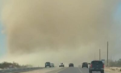
Storm coverage will be enhanced on Tuesday. Storms will originate across the high country and move toward the Valley later in the day. Strong winds and blowing dust are a good possibility across the lower deserts by the late afternoon/early evening.
Rain chances should persist over portions of the area on Wednesday before retreating to mainly over higher terrain areas late week as conditions begin to dry out. As a result of the enhanced storm and dust threat in the Valley on Tuesday, we will have a Weather Impact Alert day beginning at 3 p.m. and lasting into the evening.
Temperatures should be closer to seasonal norms during the middle of the week before heating back up into next weekend.
TUESDAY: 110/92 Mostly sunny 40% chance of storms
WEDNESDAY: 106/88 Mostly sunny 30% chance of storms
THURSDAY: 107/89 Mostly sunny
FRIDAY: 111/91 Mostly sunny
SATURDAY: 113/91 Mostly sunny
SUNDAY: 112/89 Mostly sunny
MONDAY: 109/88 Mostly sunny
Arizona Weather
Arizona has seen its fair share of severe weather throughout the state. Watch a compilation of videos from various thunderstorms, floods, and fires from across the Grand Canyon State on our 12News YouTube channel here.
If you see storms, dust, beautiful sunsets, and more and you can safely do so, please share your photos and videos with us in the 12 News app, at pictures@12news.com, or on social media using the hashtag #BeOn12.


