cct-tracking
Snowstorm Disrupts Holiday Travel Across the US

Cold air is set to blanket the eastern third of the United States beginning Monday, with temperatures expected to dip about 10 degrees below average.
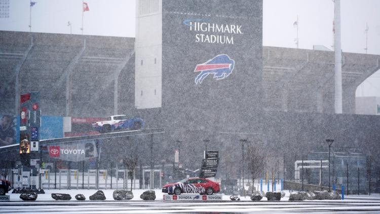
In Buffalo, New York, the first significant snowfall of the season is causing disruptions just as the holiday travel weekend unfolds. Areas along Lake Erie and northwestern Pennsylvania are experiencing heavy snow, leading forecasters to warn of dangerous conditions for Thanksgiving travelers.
A state of emergency has been declared in parts of New York, while Pennsylvania has also issued a disaster declaration. “Travel will be extremely difficult and hazardous this weekend, especially in areas where multiple feet of snow may accumulate very quickly,” the National Weather Service cautioned on Saturday.
Road closures are impacting travel; a section of I-90 in Pennsylvania has shut down, and westbound lanes of the New York Thruway are also blocked. Regions in New York, Ohio, and Michigan have already seen almost two feet of snow, with Pennsylvania recording up to 29 inches in its northwestern corner.
In northwestern Pennsylvania, conditions became so dire early Saturday that many travelers took refuge in a Holiday Inn near I-90, which was fully booked. Employees quickly adapted, transforming conference spaces into makeshift sleeping areas, providing blankets, and warming up bagels for the stranded guests.
Jeremiah Weatherley, a hotel staff member, recounted, “Everyone helped each other. It was pretty cool.” This camaraderie unfolded as guests teamed up to dig out cars buried in heavy snow.
As an Arctic air mass moves across the country, the Northern Plains are bracing for temperatures plunging to 10 to 20 degrees Fahrenheit below normal. Cold weather advisories have been issued for parts of North Dakota and beyond.
Specifically in Michigan, the phenomenon of lake-effect snow is wreaking havoc. Warm moist air from Lake Superior is mixing with colder air, leading to substantial snowfall. Reports indicate that some places in Michigan’s Upper Peninsula have accumulated over two feet of snow since Friday.
Lily Chapman, a meteorologist with the National Weather Service in Marquette, Michigan, noted that snowfall can vary dramatically, even within short distances. “In some spots in the same town, you can see a foot of snow and then just a few miles away, you could have over two feet,” she explained.
With continued snowfall expected, Michigan’s eastern Upper Peninsula could see another foot of accumulation by Monday morning. Meanwhile, western areas might experience six to ten additional inches.
In Pennsylvania, Governor Josh Shapiro enacted a disaster emergency proclamation. He reported that certain regions, like Erie County, have received nearly three feet of snow, with more anticipated through Monday night. Emergency teams have been mobilized to aid stranded drivers and ensure emergency services can operate unhindered.
During a challenging 24-hour span, Pennsylvania State Police responded to nearly 200 incidents as snowfall began to intensify on Friday.
New York state forecasters have predicted between four to six feet of blowing and drifting snow in areas east of Lake Ontario. Following an unusually mild fall, up to three feet of snow may fall along Lake Erie south of Buffalo, driven by lake-effect bands capable of delivering snow at rates of 2 to 4 inches per hour.
Erie County Public Works Commissioner William Geary remarked on the unusually warm lake temperature, stating, “That’s why we’re seeing these heavy lake-effect events.” More snow is expected as the first days of December approach.
Izaguirre reported from Lindenhurst, New York. AP Sports Writer John Wawrow contributed from Orchard Park, New York, and additional reports came from various correspondents across the northeastern United States.


